top of page


Trolley Trail
Description
This coastal pathway offers a serene journey through Branford's tidal wetlands, following the historic route of an early 20th-century electric trolley line. The trail features a combination of crushed stone, gravel, and concrete surfaces, making it accessible for various activities. A highlight is the historic iron trestle bridge, providing panoramic views of the surrounding salt marshes and glimpses of the Thimble Islands.
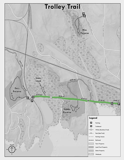
Trail Map
Map Credit: Branford Land Trust

Difficulty

The trail is flat and pretty wide throughout, with minimal obstacles. It's easy to enter and provides hikers with an easy access point to the Branford Trail.
Easy
Pictures


1/44
History
The trail follows the path of an old electric trolley line that once connected Branford to nearby towns along the shoreline. Built in the early 1900s, the trolley served residents, tourists, and workers traveling between New Haven and Stony Creek. It ran on a narrow corridor that crossed tidal marshes and offered scenic views of the coast. The line was eventually shut down as car travel became more common, but the original route remained.

Image Credit: The Shore Trolley Museum

Image Credit: Shoreline Hikes
One of the trail’s key features is the original iron trestle bridge that once carried the trolley across tidal marshes. Built to handle both the weight of the train and the harsh coastal conditions, the structure has stood for over a century. It has since been restored and reinforced for pedestrian use, now serving as one of the trail’s most iconic viewpoints. From the bridge, visitors can see expansive views of the salt marsh and even catch a glimpse of the Thimble Islands. The structure is a rare surviving piece of early electric railway infrastructure. Its presence connects modern hikers to Branford’s transportation and engineering past.
The trolley line helped shape the development of Branford’s shoreline neighborhoods in the early 20th century. With regular service between New Haven and Branford, it made coastal areas more accessible for summer visitors and encouraged the growth of seasonal cottages in places like Stony Creek and Pine Orchard. Local businesses and resorts benefited from the increased traffic, and the line became an important part of everyday life. Even after the trolley stopped running, its route continued to influence how neighborhoods and roads were laid out. The trail that remains today reflects that original path and its role in connecting communities along the coast.

Image Credit: The Shore Trolley Museum

Image Credit: The Shore Trolley Museum
After the trolley line was decommissioned, the corridor sat unused for decades. In the early 1970s, local efforts led by the Branford Land Trust and other groups helped preserve the path as a public trail. The restoration included rebuilding boardwalks, clearing brush, and adapting the space for safe, year-round access. Today, it serves both as a recreational resource and a preserved piece of Branford’s past. Additionally, the Shore Line Trolley Museum in nearby East Haven operates historic trolley rides along a preserved section of the original line, offering visitors a glimpse into the area's transportation history.
Recommended Routes
Map Credit: Branford Land Trust
This is a very nice flat, well cleared, and wide route that goes along the ocean. By taking this route you'll go over the iconic metal bridge, walk over the trolley tracks, under the bridge, and over the concrete boardwalk. This route features lots of scenic spots for great photos.

Easy

Recommended By
Trevor Cash
bottom of page